
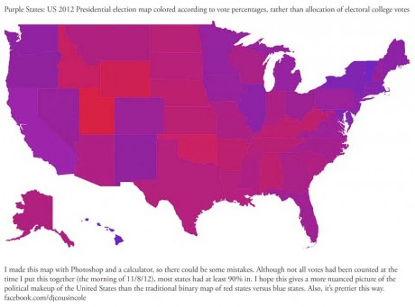
The media has portrayed a polarized country by classifying states as either red or blue. If states were categorized by voting percentages rather than electoral votes, here’s how the United States of America would look. This map was created using Photoshop values based on voting percentages by New York DJ and producer Cousin Cole.
Media
Purple States of America
/ 7
That’s interesting.
Here’s another one in which the country is colored in county by county based on election results.
patriotpost.us/perspective/15428
If only the land could vote.
I don’t think they made California blue enough.
It should be more like the color of a suicidal taxpayer’s butt sitting on an iceberg.
Maybe we can get a map of voter fraud!
How does Mitt Romney get ZERO votes in 59 Precincts in Philly, and 9 Precincts in Ohio? Impossible you say? Well it happened if you believe there was no voter fraud involved.
Romney got zero votes in at least a dozen precincts in Santa Clara County too.
http://results.enr.clarityelections.com/CA/Santa_Clara/43231/111906/en/pr.html
That’s because those precincts reported zero voters.
I guess I wasn’t too clear. If you’re going to make a case for voter fraud, you have to supply more than fragments of information. Zero out of zero isn’t compelling, zero out of hundreds or thousands is compelling.
Where’s the beef?
sorry missed the beef in your post as well. Wasn’t making a case for fraud just stating a fact jack.
Those 100% precincts were heavily African-American, as the President carried the African American community by more than 90% of the vote, it would not be unusual for him to carry a number of precincts by 100%.
The results are more a reflection of the current state of the Republican Party than any voter fraud. I haven’t looked at precincts in Utah, but I wouldn’t be surprised is some of those went 100% or close to it for Romney.